
Freycinet National Park stands as one of Tasmania’s most celebrated protected areas, drawing visitors from around the world to its dramatic granite peaks, pristine beaches, and diverse wildlife. Located on the Freycinet Peninsula along the state’s eastern coast, this 11,000-hectare park encompasses a landscape shaped by millions of years of geological activity and millennia of Indigenous stewardship.
The park’s crown jewel, Wineglass Bay, frequently appears on lists of the world’s most beautiful beaches, thanks to its distinctive curved shoreline of pure white sand and waters that shift from deep blue to turquoise. Beyond this iconic vista, Freycinet offers hiking trails ranging from short walks to multi-day adventures, camping beneath coastal skies, and opportunities to observe marine life in its natural habitat.
This guide provides essential information for planning a visit to Freycinet National Park, covering access routes, trail options, practical visitor information, and guidance for making the most of what this remarkable corner of Tasmania has to offer.
Where Is Freycinet National Park and How to Get There?
The park occupies the entirety of the Freycinet Peninsula, a landform that juts into the Tasman Sea and shelters the waters of Great Oyster Bay. The peninsula sits roughly midway along Tasmania’s eastern coastline, positioned between the cities of Hobart to the south and Launceston to the north.
Accessing the park requires ground transportation, as no scheduled public transport serves the peninsula directly. Most visitors drive from either direction along the Tasman Highway (A3), turning onto Coles Bay Road (C302) at the township of Bicheno or at the intersection near Swansea. From there, the road continues to Coles Bay, the main service centre for the park, before entering Freycinet Drive to reach the main car park near the trailheads.
The drive from Hobart takes approximately 2.5 to 3 hours, while Launceston is slightly closer at around 2 to 2.5 hours. Coles Bay itself is a small coastal settlement with basic services including a general store, fuel, and accommodation options. The Freycinet Visitor Centre operates daily from 9am to 4pm, providing maps, trail information, and current conditions before visitors head into the park.
- The peninsula forms part of the traditional Country of the Paredarerme people, who have maintained connection to this landscape for thousands of years
- Major landmarks include the Hazards—a series of pink granite peaks dominating the skyline above Coles Bay
- Great Oyster Bay lies between the peninsula and the mainland, named for the molluscs historically harvested in its waters
- Schouten Island sits off the peninsula’s eastern tip, accessible by boat tours from Coles Bay
- The park’s coastal position means weather can change rapidly throughout the day
- Seasonal whale and dolphin sightings occur in the surrounding waters during migration periods
| From | Distance | Drive Time | Route |
|---|---|---|---|
| Hobart | ~220 km | 2.5–3 hours | Tasman Highway (A3) |
| Launceston | ~170 km | 2–2.5 hours | Tasman Highway (A3) |
| Bicheno | ~30 km | 25 minutes | Coles Bay Road (C302) |
| Swansea | ~50 km | 40 minutes | Coles Bay Road (C302) |
What Is Freycinet National Park Known For?
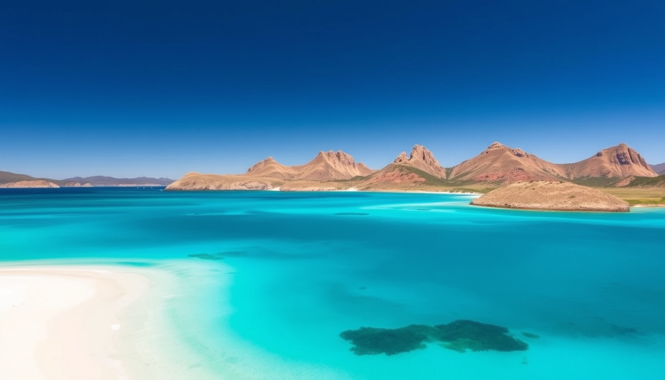
Freycinet National Park’s reputation rests primarily on the striking contrast between its towering pink granite mountains and the flawless crescent of white sand that curves along Wineglass Bay. The Hazards range, reaching elevations of around 500 metres, rises abruptly from the coastal plain, creating one of Tasmania’s most recognizable natural silhouettes. The interplay of these ancient granite formations with the turquoise waters below produces vistas that consistently rank among the state’s most photographed scenes.
The Wineglass Bay Experience
Wineglass Bay takes its name from the shape of its shoreline—a near-perfect arc of bright white sand flanked by headlands covered in coastal heathland and she-oaks. The water within the bay ranges from pale aquamarine in shallow areas near the beach to deeper blues where the bay opens toward the Tasman Sea. This chromatic variety results from the bay’s varying depths and the way sunlight interacts with the sandy bottom and seafloor marine life.
Reaching the bay itself requires either hiking to the beach via the Wineglass Bay Track or arriving by water. Those who walk to the lookout first are rewarded with the classic panoramic view that appears on countless postcards and travel publications. The beach itself offers opportunities for swimming in the calmer waters near the shore, though visitors should be aware that no lifeguards patrol the beach and conditions can change with tide and weather.
Peak visiting periods—particularly holiday weekends and Easter—can see significant crowding at Wineglass Bay Lookout and beach. Early morning arrivals (before 9am) typically encounter fewer visitors and better conditions for photography. Current conditions and any temporary closures are posted on the Tasmania Parks & Wildlife website.
Geology and Landscape Character
The granite that forms the Hazards and much of the peninsula’s interior dates back approximately 390 million years to the Devonian period. This same geological material underlies much of the Freycinet Peninsula, creating the distinctive pink hue visible when the rock is freshly exposed. Over millennia, weathering has shaped the granite into the rounded domes, tors, and boulder fields that characterize the higher ground within the park.
The coastal areas support distinct vegetation communities adapted to the challenging conditions of salt spray, poor soils, and strong winds. Heathland dominated by banksias, wattles, and endemic Tasmanian plants covers the lower slopes, while tall eucalypts occupy the sheltered valleys and southerly aspects. This variety in habitats supports correspondingly diverse wildlife, from wallabies and possums in the forest understory to seabirds circling the clifftops.
What Are the Best Hikes in Freycinet National Park?
Freycinet National Park offers trails suited to a wide range of fitness levels and time constraints, from brief walks to multi-day expeditions. All major trailheads begin from the main car park at the end of Freycinet Drive, where information boards display current conditions and safety advisories. GPS files for several routes are available through various hiking resources and online communities dedicated to Tasmanian bushwalking.
Short Walks and Lookouts
The Wineglass Bay Lookout track stands as the park’s most popular short walk, classified as one of Tasmania’s 60 Great Short Walks by the state government. The 2.6 to 3 kilometre return route climbs steadily through bushland before emerging at a viewing platform overlooking the full sweep of Wineglass Bay. Most walkers complete the journey in 1 to 1.5 hours, though the pace varies considerably depending on fitness and the number of stops for photographs and rest.
For those wishing to continue to the beach itself, the track descends steeply from the lookout to the sand, adding approximately 40 minutes to an hour of travel each way. The return distance for this extended option is roughly 6 kilometres. Swimming is possible at the beach, but visitors should exercise caution regarding conditions and never turn their back on the ocean.
| Trail | Distance | Time | Difficulty |
|---|---|---|---|
| Wineglass Bay Lookout | 2.6–3 km return | 1–1.5 hours | Moderate |
| Wineglass Bay Beach | 6 km return | 2–3 hours | Moderate |
| Mount Amos | 3.6–4 km return | 2–3 hours | Difficult |
Longer Circuits and Multi-Day Walks
The Wineglass Bay and Hazards Beach Circuit represents the park’s signature full-day hike, combining the classic lookout views with beach walking and coastal scenery. This 11 to 12 kilometre loop begins at the Fisheries car park and takes most walkers 3 to 5 hours to complete, depending on fitness and how much time is spent at various points along the route.
The circuit passes through several distinct landscapes: dry forest, coastal heathland, and long stretches of beach walking. At the isthmus between Wineglass Bay and Hazards Beach, hikers cross from one side of the peninsula to the other, with opportunities to explore tidal pools and observe marine life in the shallows. The Hazards Beach section offers views back toward the granite peaks that dominate the western skyline.
For experienced hikers seeking a more immersive experience, the Freycinet Peninsula Circuit traverses the entire length of the peninsula over 2 to 3 days, covering approximately 27 kilometres of sometimes rugged terrain. This route requires advance booking through the Parks Pass system and overnight stays at designated campgrounds at Hazards Beach, Cooks Beach, and Wineglass Bay.
Mount Amos involves steep scrambling over exposed granite and is not recommended during or after wet weather when the rock becomes dangerously slippery. Rest seats are available at intervals along the Wineglass Bay Lookout track, making that route more accessible for those who cannot manage sustained steep climbs without breaks.
Other Activities Beyond Hiking
While hiking dominates most visitors’ itineraries, Freycinet offers additional ways to experience its landscapes. Kayaking and paddleboarding operators based in Coles Bay provide guided excursions into Wineglass Bay, often combining water-based activities with beach walks and wildlife spotting. These tours frequently encounter dolphins in the bay’s protected waters, and occasional seal sightings occur near the rocky headlands.
Boat tours departing from Coles Bay circle the peninsula and continue to Schouten Island, offering perspectives of the coastline that cannot be achieved from land. These excursions typically run for several hours and may include commentary on the park’s natural and cultural history. Departure times and booking availability vary seasonally, with more frequent services during the summer months.
Freycinet National Park Fees, Camping, and Best Time to Visit
Entry and Access Costs
All visitors to Freycinet National Park must purchase a Parks Pass before entering, with this requirement applying year-round regardless of the season. The pass system operates through the Tasmania Parks and Wildlife Service and offers several pricing tiers depending on the duration and type of visit. Day passes, holiday passes, and annual passes provide flexibility for different visitor needs.
Vehicle-based passes cover all occupants of a single vehicle, making them cost-effective for groups traveling together. Holiday passes provide unlimited entry during a defined period and represent good value for those planning multiple park visits within Tasmania during a single trip. Purchase is available online through the Parks Tasmania website or in person at the Freycinet Visitor Centre upon arrival, though buying online in advance is recommended during busy periods.
Parking at the main trailhead car park is provided free of charge, though during peak holiday periods the lot fills early and overflow parking along the roadside becomes necessary. No shuttle bus services operate within the park, making private vehicle access or organized tour transport the only options for reaching the trailheads.
Campsites within the park must be reserved in advance through the Parks Pass system, particularly during summer and holiday weekends. Walk-up camping without a pre-booked site is not permitted. Specific fee structures for camping are set by the Parks and Wildlife Service and may vary from year to year; current pricing should be confirmed directly through parks.tas.gov.au before planning a trip.
Camping and Overnight Stays
Freycinet offers walk-in camping at three locations within the park: Hazards Beach, Cooks Beach, and Wineglass Bay. All sites are accessible only by foot, with distances from the nearest vehicle parking ranging from approximately 3 to 6 kilometres depending on the destination. This walk-in approach helps limit environmental impact and maintains a more natural atmosphere than drive-in camping would provide.
Facilities at the campgrounds are basic, comprising composting toilets, tent platforms or cleared areas, and rainwater collection for drinking water. Campers should carry sufficient food and water for their stay and must pack out all rubbish. Campfires are generally prohibited except in designated fire pits where provided, and total fire bans may be imposed during periods of high fire danger.
When to Visit
The park is accessible throughout the year, with each season offering a different character. Summer months from December through February bring the warmest temperatures and longest daylight hours, making them ideal for beach activities, swimming, and extended day walks. This popularity comes with a cost: holiday weekends and particularly Christmas/New Year and Easter see substantial crowds, with parking filling by mid-morning and popular tracks becoming busy.
Autumn and spring offer a middle ground, with fewer visitors but potentially more variable weather. These shoulder seasons can be excellent times for serious hikers who want to avoid crowds while still enjoying reasonable daylight hours and relatively mild conditions. Winter brings shorter days and colder temperatures, though rainbows often appear after passing showers and the park’s landscapes take on a different mood under overcast skies.
Weather in the park can change rapidly due to its coastal position. Visitors should check the Bureau of Meteorology forecast for Coles Bay before heading out, particularly during cooler months when hypothermia risk exists for ill-prepared walkers caught in sudden rain or wind events. The steep sections of most tracks become slippery when wet, requiring appropriate footwear and careful footing.
History and Development of Freycinet National Park
The land that now comprises Freycinet National Park has a human history stretching back at least 35,000 years, based on archaeological evidence from nearby sites on the Tasmanian mainland. The Paredarerme people were the traditional custodians of this country, managing the landscape through cultural burning practices and sustainable resource use for countless generations before European arrival.
- 1916: Freycinet National Park is established, becoming one of Tasmania’s earliest protected areas
- 1975: The park is expanded to include additional coastal land, increasing protection for significant habitats
- 1992: Walk-in camping introduced at Hazards Beach, Cooks Beach, and Wineglass Bay
- 2000s: The park receives consideration for tentative listing on the UNESCO World Heritage register as part of broader natural landscape nominations
- 2022–2024: Trail infrastructure upgrades improve safety and sustainability along popular routes, with particular attention to the Wineglass Bay Lookout track
The establishment of the park in 1916 reflected a growing awareness of the need to protect distinctive natural landscapes from development and over-exploitation. Early visitors to the peninsula arrived by boat, landing at sheltered coves to explore before the era of road access transformed how people experienced the area. The construction of the road to Coles Bay in the mid-twentieth century opened the park to vehicle-based tourism, fundamentally altering visitor patterns and numbers.
Confirmed Information and Areas of Uncertainty
Visitors should be aware that certain details about Freycinet National Park are well-established and verifiable, while others may vary or remain unclear depending on current conditions and official sources.
| Established Information | Information Requiring Verification |
|---|---|
| Parks Pass required for entry | Specific fee amounts for 2024 season |
| Visitor Centre hours (9am–4pm daily) | Exact camping fees per site per night |
| Main trails: Lookout (3 km), Circuit (11–12 km), Mount Amos (3.6–4 km) | Current shuttle or transport service availability |
| Three walk-in campgrounds available | Seasonal wildlife activity timing |
| No dogs permitted in the park | Specific temporary closures (check official site) |
For the most current and accurate information on fees, closures, and conditions, visitors should consult the official Tasmania Parks and Wildlife Service website before their visit. Conditions can change quickly, particularly during extreme weather events or fire danger periods.
Wildlife, Conservation, and Sustainable Visitation
The waters surrounding Freycinet Peninsula support rich marine biodiversity, with dolphins, seals, and migrating whales appearing in the area at various times of year. Bottlenose dolphins are resident in Great Oyster Bay year-round, while humpback and southern right whales pass through during their annual migration between Antarctic feeding grounds and warmer breeding waters. Guided kayak and boat tours offer the best opportunities for wildlife observation, as these operators know the areas where animals are most frequently encountered.
Land-based wildlife includes common wallabies, pademelons, and various bird species adapted to the coastal environment. Wedge-tailed eagles nest in the granite areas and can be seen soaring on thermal currents above the peaks, while seabirds including albatrosses and petrels inhabit the offshore waters. Staying on marked tracks helps protect the sensitive coastal heathland and its inhabitants from disturbance.
The park faces ongoing pressure from its popularity. Social media has amplified visitor numbers, with images of Wineglass Bay circulating widely and inspiring trips by visitors who might not otherwise have considered a Tasmanian adventure. This increased visitation has led to impacts on vegetation near popular sites, erosion on informal shortcuts, and strain on facilities designed for lower use levels. Rangers and conservation groups continue working to address these challenges through trail improvements, visitor education, and visitor number management strategies during peak periods.
Visitor Experiences and Perspectives
The Tasmania Parks and Wildlife Service describes Freycinet as offering “one of the most beautiful coastal landscapes in the world,” with the Wineglass Bay area consistently cited as the park’s highlight. Rangers stationed at the visitor centre provide firsthand guidance on current trail conditions, wildlife viewing opportunities, and safety considerations for the day’s visit.
The view from Wineglass Bay Lookout remains one of Tasmania’s most photographed scenes, representing the ideal of wilderness beauty that draws visitors to the state’s national parks.
— Tasmania Parks and Wildlife Service
Traveller accounts frequently emphasize the reward offered by the climb to Wineglass Bay Lookout relative to the moderate effort required. Many visitors who complete the circuit hike describe it as the highlight of their Tasmanian journey, citing the variety of landscapes encountered—from eucalypt forest to heathland to open beach—and the sense of accomplishment from navigating a longer track through such striking scenery.
Planning Your Freycinet National Park Visit
A visit to Freycinet National Park works well as either a day trip from Launceston or Hobart, or as part of a longer Tasmanian east coast itinerary that includes destinations like Maria Island, the Bay of Fires, or the wineries near the Tamar Valley. The park deserves more than a few hours if time allows, but even a half-day visit to the Wineglass Bay Lookout provides access to one of the state’s signature landscapes.
Essential preparations include purchasing a Parks Pass before arrival, carrying sufficient water for the planned activity level, wearing appropriate footwear with good grip, and checking current weather conditions. Those planning overnight stays should book campsites well in advance, particularly during school holidays. Sun protection is important year-round given the exposed nature of many trail sections.
For those seeking additional perspectives on Australian experiences beyond Tasmania, detailed information on other iconic destinations is available in related guides such as the Sydney Bridge Climb Guide and the Sydney Bridge Climb 2025 Guide.
Where should I stay near Freycinet National Park?
Coles Bay provides the closest accommodation options, including holiday homes, cabins, and camping grounds. Swansea and Bicheno offer additional options within 30–50 minutes’ drive of the park entrance.
Is Freycinet National Park worth visiting?
The park consistently ranks among Tasmania’s top attractions, with Wineglass Bay appearing on numerous lists of the world’s most beautiful beaches and lookouts. The combination of accessible hiking, coastal scenery, and wildlife opportunities makes it worthwhile for most visitors to the state.
Do I need to book ahead to visit Freycinet?
Day visits require only a Parks Pass, which can be purchased online or at the visitor centre. Campsites must be booked in advance through the Parks Pass system, especially during peak seasons and holiday periods.
Can I bring my dog to Freycinet National Park?
No, dogs and other domestic pets are not permitted within Freycinet National Park at any time, in accordance with park regulations designed to protect native wildlife.
Are there facilities at Wineglass Bay beach?
Wineglass Bay beach has no facilities beyond what visitors carry in. Toilets, drinking water, and other services are available at the main car park and visitor centre near the trailhead.
What should I pack for a day hike at Freycinet?
Essential items include sturdy footwear, at least one litre of water per person, sun protection, rain gear, and basic first aid supplies. Snacks or lunch are recommended for longer hikes.
Can I swim at Wineglass Bay?
Swimming is possible but unsupervised. The beach has no lifeguards, and conditions can change rapidly with tides and weather. Care should be taken regarding marine stingers in warmer months.
Related stories


Liam O'Brien covers Australian politics and public affairs for Coast Pulse.